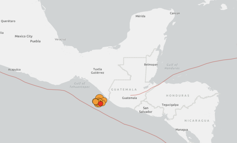
The Mexican Naval Tsunami Warning Center canceled the alert after analyzing coastal sea-level behavior near the epicenter, confirming that hazardous waves were not expected. However, the U.S. Tsunami Warning System had initially warned that dangerous waves could reach coasts within 300 kilometers of the epicenter. Despite the cancellation, the Marine Secretariat advised residents to avoid beaches for six hours due to the risk of strong currents affecting maritime activities such as swimming, diving, and fishing.
President Claudia Sheinbaum stated that she had communicated with the governors of Chiapas and Tabasco, both of whom reported no material damage or casualties in their respective states. Sheinbaum noted that emergency protocols had been activated in neighboring states. Chiapas Governor Eduardo Ramírez reported that “so far we have nothing to lament,” while Oaxaca Governor Salomón Jara described the shaking in the state capital as being of “moderate intensity” with no significant damage. As of midday Friday, authorities reported approximately 80 aftershocks, the largest of which measured 6.5 in magnitude.
Minor damage was documented in Chiapas, including structural cracks in several buildings. Two individuals were injured in Tapachula: one person fell while jumping from a third-floor window during the quake, and another was hurt by a falling door. In Guatemala, the 5.6-magnitude tremor caused the evacuation of President Bernardo Arévalo and other government officials from the National Culture Palace. Residents in Guatemala City reported the shaking lasted approximately 12 seconds, significantly longer than the typical three to five seconds for local seismic events. El Salvadoran authorities ruled out tsunami risks but urged caution in coastal areas.
The failure of the national seismic alert system to issue an immediate warning to residents in Chiapas has raised concerns about monitoring coverage. Mexico’s Digital Platform for Early Warning and Comprehensive Risk Management (SASSLA) explained that the lack of sensor systems in Chiapas meant the earthquake was only detected when its energy reached sensor stations in neighboring Oaxaca, at which point it no longer exceeded the pre-set thresholds required to trigger the automated alert. SASSLA noted that the system detected the event only after it had already passed through the immediate epicentral region.
Mexico is situated within the Pacific “Ring of Fire,” a tectonically active zone characterized by frequent earthquakes and volcanic activity. Southern Mexico is particularly vulnerable due to the subduction of the Cocos Plate beneath the North American Plate, a geological configuration that generates significant seismic and tsunami potential. The region has a long history of powerful offshore earthquakes, making early warning infrastructure a critical component of disaster risk management.
In a separate incident earlier this month, seismographs in Mexico City recorded vibrations resembling a small earthquake during a World Cup soccer match against Germany. The National Seismological Service later clarified that the readings were attributed to two small, unrelated earthquakes occurring around the time a goal was scored, rather than the collective movement of thousands of fans celebrating in public squares. This event highlighted the sensitivity of Mexico’s seismic monitoring network to both natural and anthropogenic vibrations.
Authorities continue to monitor the region for further aftershocks. Geologists and civil defense officials are assessing the extent of minor structural damage in Chiapas to ensure public safety. No further tsunami risks are currently anticipated, and maritime activities are expected to resume as normal once the six-hour coastal advisory period concludes.