
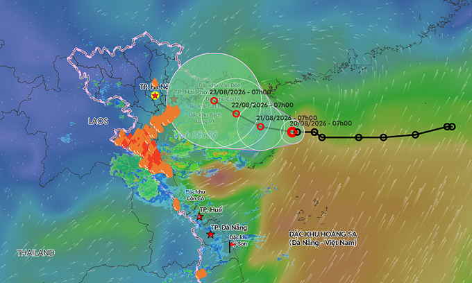
As of the latest observations on August 24, the center of Narra was positioned near 19.9°N, 108.0°E. The system is expected to remain almost stationary through August 25, with a slight southward shift within the same general area. By August 26, the storm is projected to begin drifting slowly northeast, with its center moving toward the Leizhou Peninsula and Hainan Strait area of southern China. While the system is stationary, it continues to generate onshore winds and swell that have accumulated over a fixed area, leading to hazardous sea conditions and reduced visibility for mariners transiting the Gulf of Tonkin and the northern South China Sea.
Forecasts indicate a steady weakening trend for Narra over the next two days. The storm is expected to remain classified as a tropical storm through August 25, with central pressure rising slightly from 992 hPa to 994 hPa. Maximum sustained winds are easing from 40 knots (74 km/h) to 35 knots (65 km/h), with gusts reaching up to 50 knots (93 km/h). By August 26, the system is forecast to transition to tropical depression status, with central pressure rising further to 996 hPa. Confidence in the exact timing of this transition is considered moderate due to the storm’s unusual stalling behavior, though the consistent rise in central pressure confirms the favored weakening trend.
Maritime Disruptions and Coastal Warnings
The prolonged presence of the storm over the Gulf of Tonkin has triggered strict warnings for maritime activities. The National Civil Defense Steering Committee has urged local authorities, ministries, and agencies to closely monitor the depression and strictly manage offshore maritime traffic. Fishing operations and coastal shipping lanes are affected by rough seas and storm surge, which may persist near the coast even as the system weakens. Winds over the eastern Gulf of Tonkin are gradually intensifying, with sustained winds reaching 39 to 61 km/h and gusts up to 88 km/h, whipping up waves between two and three meters high.
Earlier forecasts for a tropical depression east of China’s Hainan Island have been integrated into the broader tracking of Narra. The system was previously noted moving west at 5 to 10 km/h, with maximum winds of 49 km/h and gusts up to 74 km/h. As it crosses northern Hainan Island, its intensity is expected to remain steady before it shifts west-northwest. The slow movement allows wind and wave energy to build over a fixed area, maintaining hazardous conditions for coastal communities in northern Vietnam and southern China until the system fully transitions to a tropical depression.
Officials continue to advise mariners to expect reduced visibility and dangerous sea conditions through August 26. The stalling nature of the typhoon means that while the peak intensity may be receding, the cumulative effects of heavy rain and strong winds on coastal infrastructure and agriculture remain a primary concern. Monitoring updates will continue as the system drifts toward the Hainan Strait, with forecasters closely watching for any changes in forward motion that could alter the local impact along the coastlines of Vietnam and China.