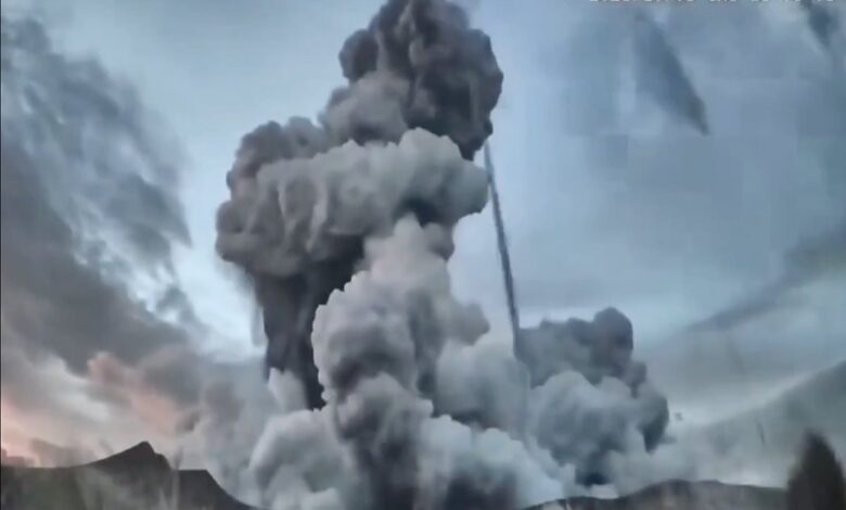
This recent activity is part of a broader pattern of volcanic unrest across the Philippines, an archipelago situated along the Pacific “Ring of Fire,” where tectonic plate collisions drive frequent seismic and volcanic activity. While Taal’s eruption was brief, it joins a series of significant events that have strained local infrastructure and displaced thousands of residents in recent years. In December 2024, Kanlaon Volcano, located on the central island of Negros, erupted for nearly four minutes, shooting an ash column 2.5 miles (approximately 4,000 meters) into the sky. Unlike the localized evacuations at Taal, the Kanlaon event triggered an urgent evacuation operation affecting approximately 87,000 residents. The eruption produced a deadly spurt of hot ash, gases, and fragmented volcanic rock that traveled about two miles down the mountain’s southeast flank, prompting the government to raise the alert level to indicate the potential for further explosive eruptions.
The environmental and health impacts of these eruptions are documented and severe. Maria Antonia Bornas, the volcano monitoring chief at PHIVOLCS, described the danger of pyroclastic density currents—fast-moving flows of hot gas and volcanic matter—as being like being “run over by a high-speed vehicle.” She warned that ash inhaled into the lungs can cause asphyxiation, a risk compounded by the release of toxic gases such as sulfur dioxide. During the Kanlaon eruption, ash fell across a wide area, including Antique province, some 120 miles to the west, obscuring visibility and creating health risks. Authorities also cautioned that heavy rain could dislodge fresh volcanic sediment, potentially burying communities below. The aviation sector felt the immediate impact, with the Philippine Civil Aviation Authority canceling about half of a dozen domestic flights and one international flight to Singapore. Carriers were advised to avoid flying below 10,000 feet near the volcano due to hazards from steam-driven or phreatic eruptions.
While Kanlaon’s activity led to mass displacement, other volcanoes have shown different patterns of unrest. In June 2023, Mayon Volcano, the country’s most active stratovolcano, exhibited increasing signs of activity, including incandescent lava and tremors that forced the evacuation of 17,000 people within its six-kilometer danger perimeter. PHIVOLCS officials noted that while the chances of an immediate explosive eruption were low at the time, the seismic energy charted over months showed consistent activity. Mayon’s last Plinian eruption, characterized by extreme explosivity, occurred in 1814 and killed at least 1,200 people. More recently, in 2018, increased activity at Mayon displaced over 66,000 people and caused agricultural damage estimated at 185 million Philippine pesos ($3.5 million). These historical and recent precedents illustrate the range of volcanic hazards, from steam-driven phreatic events to magma-driven eruptions that can last for months.
The scientific consensus, supported by agencies like the U.S. Geological Survey (USGS) and PHIVOLCS, links these events to the geological reality of the Philippines’ position on the Ring of Fire. Major explosive eruptions can launch large amounts of volcanic material into the atmosphere, with gases like sulfur dioxide capable of causing global cooling. For instance, the 1991 eruption of Mount Pinatubo ejected 20 million metric tons of sulfur dioxide into the stratosphere, cooling the planet by up to 1.3°F at peak impact. Conversely, some research suggests a warming climate may influence volcanic frequency and the dispersion of eruption plumes. A 2021 study from the University of Cambridge found that as the planet warms, smoke and fumes from eruptions can rise higher and travel farther, potentially exacerbating local and regional impacts.
Despite the clear geological drivers, uncertainties remain regarding the timing and magnitude of future eruptions. At Taal, PHIVOLCS continues to prohibit entry to the island, designated a Permanent Danger Zone, while monitoring for changes in seismic activity and gas emissions. At Kanlaon, which has erupted more than 40 times since 1866, the alert level remains elevated, and residents in upland villages like those in La Castellana have faced ongoing evacuation orders. The human cost extends beyond immediate physical danger; prolonged displacement disrupts livelihoods, with agriculture officials estimating that over 5,700 hectares of crops could be affected by a massive eruption at Mayon alone. As the Philippines continues to monitor its 24 active volcanoes, the interplay between natural volcanic processes and climate factors presents a complex environmental challenge that requires sustained vigilance and adaptive community responses.