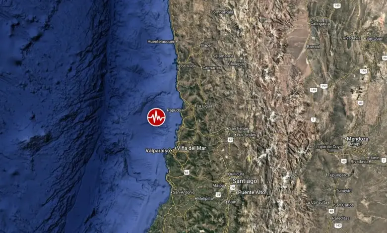
Epicenter Location and Regional Impact
The epicenter was located 36 kilometers (22 miles) northwest of Valparaíso, a coastal city with a population of approximately 282,448. The tremor was also felt in other major population centers in the Valparaíso Region. Viña del Mar, located 40 kilometers (25 miles) southeast of the epicenter, has a population of roughly 294,551. Other affected areas included Quilpué (50 km away), Villa Alemana (55 km away), and Quillota (58 km away), with populations ranging from 67,779 to 130,263 residents.
Seismic models indicate that an estimated 51,000 people experienced moderate shaking, while approximately 8.4 million and 2.26 million people felt light and weak shaking, respectively. The broad reach of the tremor reflects the shallow depth of the earthquake, which allows seismic waves to reach the surface with less attenuation than deeper events.
Safety Assessment and Infrastructure Vulnerability
The USGS issued a green alert for this event, the lowest level on its shaking-related fatality and economic loss scale. This classification signifies a low likelihood of casualties and significant structural damage. The assessment notes that the majority of the regional population resides in structures designed to be resistant to earthquake shaking, a standard practice in Chilean construction following decades of seismic activity.
However, the alert highlights the presence of vulnerable building types in the region, specifically adobe block and rubble or field stone masonry construction. These older or informal structures are less capable of withstanding strong lateral forces. Historical seismic activity in this specific area has previously triggered secondary hazards, including landslides and soil liquefaction, which can contribute to infrastructure losses even when primary structural damage is limited.

Tsunami Risk and Seismological Context
Authorities confirmed there is no tsunami threat associated with this earthquake. The magnitude and shallow nature of the event, while capable of generating intense ground motion, did not produce the displacement of water volume necessary to generate a significant tsunami wave. The event occurred in a seismically active region where the Nazca Plate subducts beneath the South American Plate, a tectonic interface responsible for the majority of significant seismicity in South America.
The consistency in magnitude reporting between the USGS and EMSC provides a reliable baseline for assessing the energy release of the event. While the magnitude of 6.0 is substantial, the specific location offshore and the depth profile resulted in a manageable risk profile for the coastal cities. The absence of reported major infrastructure failures or casualties aligns with the low-risk green alert designation. Continued monitoring by seismological agencies will track any aftershocks, though the initial event appears to have released sufficient stress to stabilize the immediate fault segment.