The approach of the storm triggered a series of high-level alerts across the Gulf Coast, underscoring the severity of the threat. A Hurricane Warning was in effect from Ocean Springs, Mississippi, to the Bay/Gulf County line in Florida. Residents within this zone were advised that hurricane conditions, including dangerous winds and potential damage, were expected, prompting officials to urge the public to complete all necessary preparations as soon as possible. The warning area reflects the broad geographic footprint of the storm’s impact, stretching across state lines from the northern reaches of the Florida Panhandle into southern Mississippi.
Beyond the core hurricane warning zone, Tropical Storm Warnings extended the scope of the threat. These warnings covered the area from the Plaquemines Parish line in Louisiana to west of Ocean Springs, Mississippi, as well as the region east of the Bay/Gulf County line to the Aucilla River in Florida. In these sectors, tropical-storm conditions were anticipated, characterized by strong winds and the possibility of power outages. The distinction between hurricane and tropical storm warnings highlights the varying intensity of the storm’s effects as it traversed the coastline, with the most severe impacts concentrated in the central landfall area.
One of the most critical aspects of the storm’s impact was the risk of flooding. A Storm Surge Warning was active from the mouth of the Mississippi River to the Steinhatchee River in Florida. This type of warning indicates the potential for life-threatening flooding caused by rising water moving inland from the coast. Such surges can occur rapidly and extend far beyond the immediate shoreline, posing significant risks to infrastructure and residential areas in coastal communities. The combination of high winds and storm surge created a compounded hazard for residents in the affected regions.

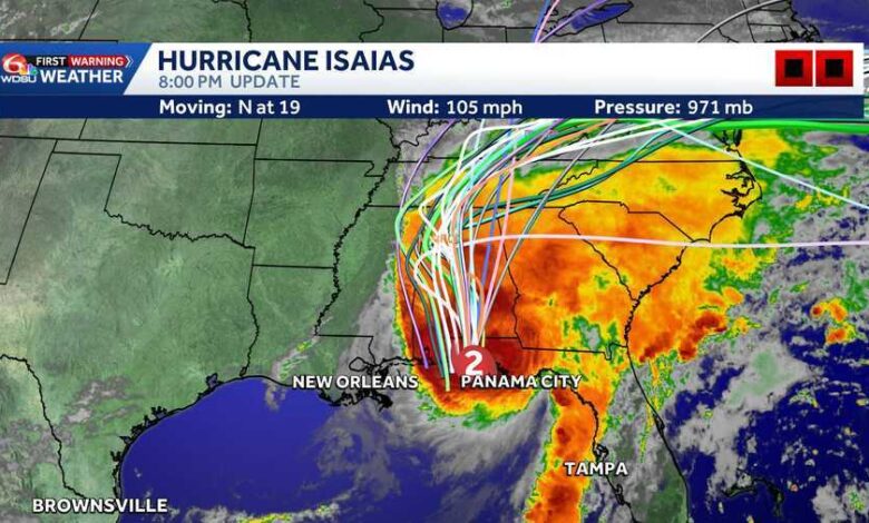
The meteorological trajectory of Hurricane Isaias was closely monitored through various predictive tools, including interactive storm radar, satellite imagery, and model data. The “spaghetti models,” which display a range of potential future tracks from different computer forecasts, were utilized to assess the storm’s path and intensity. Prior to landfall, the storm was noted for its strengthening into a major hurricane, a designation that applies to storms with sustained winds of 111 miles per hour or greater. The National Hurricane Center provided specific guidance on the storm’s movement, confirming the expected landfall time and location, which allowed for the precise issuance of the warnings described above.
As the storm moved over land, the focus shifted to the immediate effects on the region. The rapid deterioration of conditions across the Gulf Coast, with tropical-storm force winds and heavy rain moving over Alabama and Florida, marked the transition from pre-landfall preparation to post-landfall impact. The storm’s intensity, with winds reaching 120 miles per hour, placed it firmly in the major hurricane category at the time of its approach. The geographic spread of the warnings, spanning from Louisiana to Florida and including areas in Mississippi, illustrates the extensive area affected by the storm’s circulation.
The presence of such a powerful system necessitates a coordinated response from emergency management agencies and local authorities. The warnings issued, ranging from hurricane to storm surge, reflect a tiered approach to risk communication, ensuring that residents in different zones are aware of the specific threats they face. The emphasis on completing preparations in the hurricane warning area underscores the limited time available for safety measures once the storm’s landfall is imminent. The heavy rain accompanying the winds also poses a risk of flash flooding in areas not directly in the path of the strongest winds, further complicating the emergency response.

In the hours following landfall, the primary concerns for the affected areas included the assessment of damage to infrastructure, the restoration of power services, and the monitoring of flood levels. The storm’s movement inland would likely lead to a gradual weakening of wind speeds as it moved away from the energy source provided by the warm ocean waters. However, the heavy rain could continue to produce significant flooding, particularly in low-lying areas and near river systems. The situation remained dynamic, with conditions continuing to evolve as the storm system moved across the region.
The event serves as a stark reminder of the potential power of hurricanes making landfall on the Gulf Coast. The combination of high winds, heavy rain, and storm surge creates a multi-faceted threat that requires robust preparedness and response strategies. The specific details of the storm’s track, intensity, and the resulting warnings provide a clear picture of the severity of the event and the areas most at risk. As the storm dissipated or moved further inland, the focus would turn to the aftermath, including damage assessments and recovery efforts in the affected communities.