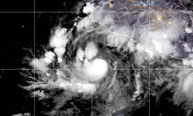
As of early Friday, October 9, 2026, Simon was classified as a Category 1 hurricane with maximum sustained winds of 150 kph (90 mph). The storm was moving northwest at 7 kph (5 mph), centered approximately 345 kilometers (215 miles) south of Manzanillo and 515 kilometers (320 miles) south-southeast of Cabo Corrientes. A hurricane warning has been issued for parts of the central and southwest coast, where hurricane-force winds are expected to arrive within 36 hours.
Rapid Intensification and Erratic Movement
Forecast models indicate that Simon will turn northward by early Saturday, altering its trajectory to approach the coast directly. The U.S. National Hurricane Center in Miami expects the storm to undergo rapid intensification, reaching Category 4 status on the Saffir-Simpson scale. Category 4 hurricanes are defined by maximum sustained winds ranging from 210 to 250 kph (130 to 156 mph), a significant upgrade from its current Category 1 classification.
The storm’s path has been described as highly erratic, with its center shifting between targeting Manzanillo and Puerto Vallarta. This unpredictability has complicated response efforts, as local authorities must prepare for high-impact precipitation across a broad stretch of the coastline. Governor Pablo Lemus of Jalisco emphasized the volatility of the system, urging the public to remain informed given the hurricane’s changing direction.
“What is certain is that it will hit the coast of Jalisco with very heavy rains starting this Friday, throughout the weekend, and on Monday,” said Governor Lemus.
Emergency Measures and Evacuations
In response to the imminent threat, the state of Jalisco has suspended classes in 22 coastal municipalities for Friday and Monday. Civil protection authorities have begun evacuating dozens of residents from at-risk areas. The state director of civil protection, Sergio Ramírez, highlighted the urgency of pre-emptive action, warning that hesitation could lead to loss of life.
“If we let our guard down and try to come up with a last-minute action plan, it is highly likely that lives will be lost,” said Sergio Ramírez, the state director of civil protection.
Specific directives have been issued for the tourism sector in Puerto Vallarta. Authorities have asked hotel operators and other tourism businesses to ensure that both employees and visitors are fully accommodated in designated shelters or safe zones by Friday afternoon. This measure aims to secure the safety of the large transient population typically present in the region during the late summer and early autumn travel seasons.
Forecasted Rainfall and Flooding Risks
Beyond the wind-related hazards, Simon is expected to produce torrential rainfall that could cause widespread flooding and mudslides. U.S. forecasters estimate that 20 to 38 centimeters (8 to 15 inches) of rain could fall in southwestern Mexico, with isolated areas potentially receiving up to 63 centimeters (25 inches). Such heavy precipitation over short periods poses a severe risk of flash flooding and landslides, particularly in mountainous terrain adjacent to the coast.
Tropical storm conditions were possible along the coast as early as later Friday, with the most severe impacts expected to occur over the weekend and into Monday. The convergence of rapid intensification, erratic movement, and extreme rainfall forecasts underscores the complexity of the threat. As the storm approaches, monitoring of its path and intensity remains critical for coordinating emergency response and minimizing impact on both local communities and the region’s tourism economy.