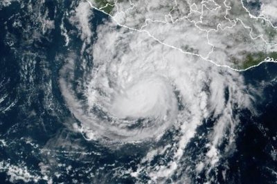
The central development of this event is the strength and trajectory of Trudy relative to densely populated and economically significant coastal areas. The storm’s classification as a Category 2 hurricane indicates a system capable of causing extensive damage, particularly to structures and infrastructure exposed to high-velocity winds and associated storm surge. The NHC’s data provides the critical scientific baseline for understanding the immediate risk: the storm is not merely approaching but is actively bearing down on the coastline with sustained force. The movement vector, traveling north-west at 10 mph, suggests a steady progression toward landfall or a close pass that will determine the exact nature of the environmental and human impact in the hours following the observation.
Currently, a hurricane warning is in effect for a specific coastal stretch defined by two key geographic markers: Manzanillo in Colima state and Cabo Corrientes in Jalisco. This designation signifies that hurricane conditions are expected within the warning area. The inclusion of these two locations highlights the geographic scope of the threat, affecting both the Colima and Jalisco states. Manzanillo, a major port city, and Cabo Corrientes, a peninsula area in Jalisco, represent distinct but adjacent zones of vulnerability. The warning implies that residents and businesses in these areas are facing imminent risks associated with tropical cyclone activity, including strong winds, heavy rainfall, and potential coastal flooding.
The scientific evidence guiding these alerts is derived directly from the NHC’s continuous monitoring of the storm’s characteristics. The measurement of 100 mph maximum sustained winds is the defining metric for the Category 2 classification, placing Trudy in a tier of hurricanes that pose a serious threat to life and property. The distance metrics provided by the NHC—205 miles from Cabo Corrientes and 115 miles from Manzanillo—offer a clear temporal horizon for the expected impact. These figures allow emergency planners to calculate the remaining time before the storm’s outer bands reach the coast, enabling the finalization of evacuation plans and resource deployment. The consistency of the data between the general report of the storm moving closer and the specific NHC metrics ensures a unified understanding of the threat level among researchers and public safety officials.
The affected populations in the Manzanillo to Cabo Corrientes corridor are those directly exposed to the storm’s projected path. While the sources do not provide specific community testimonials or detailed descriptions of local preparedness measures, the issuance of a formal hurricane warning indicates that official protocols are engaged. The economic and social implications of such a storm are inherent in the geographic location; as coastal cities, Manzanillo and areas around Cabo Corrientes are vulnerable to the physical forces of a Category 2 hurricane. The impact extends beyond immediate safety concerns to include potential disruptions to transportation, supply chains, and daily life in the south-western and west-central Pacific coast regions.
Natural factors driving this event include the atmospheric and oceanic conditions that allowed Trudy to strengthen as it moved toward the coast. The storm’s intensification to Category 2 prior to reaching the warning zone suggests favorable environmental conditions for tropical cyclone development. Human factors are primarily reactive, manifested in the issuance of warnings and the subsequent actions taken by local authorities and residents to mitigate risk. The coordination between the NHC’s scientific assessment and the local implementation of warnings represents the standard operational framework for managing hurricane threats in this region.
Adaptation and policy responses are currently focused on immediate hazard mitigation. The primary response is the communication of risk through the hurricane warning, which serves as the directive for emergency preparedness. Conservation and long-term environmental adaptation are not the immediate focus of this acute weather event, but the protection of coastal infrastructure and human life is paramount. The NHC’s role is to provide accurate, timely data, while local governments are responsible for translating that data into actionable public safety measures. The effectiveness of these responses will depend on the speed of public compliance with official advisories and the robustness of local emergency services.
Uncertainties remain regarding the exact path and intensity of Trudy as it approaches the coast. Meteorological forecasts are subject to change as the storm interacts with local topography and ocean currents. The current data reflects the state of the storm at the time of the NHC report on Saturday, but the final impact will depend on how the system evolves in the critical hours before landfall or closest approach. There is no information available in the current sources regarding specific damage estimates or casualty figures, as the storm has not yet made landfall or caused documented impact in these specific locations. The focus remains on the prevention of harm through timely warning and preparedness.
The development of Hurricane Trudy underscores the ongoing vulnerability of Mexico’s Pacific coast to tropical cyclones. The precise tracking of the storm’s movement and intensity by the NHC provides a clear picture of the immediate threat to the Manzanillo-Cabo Corrientes corridor. As the storm continues its north-westward movement, the situation will remain dynamic, with further updates expected from the NHC. The resilience of the affected communities will be tested in the coming hours, with the primary goal of ensuring public safety through adherence to official warnings and emergency procedures.