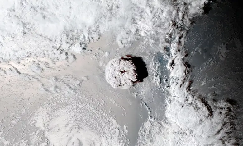
Before the eruption, the caldera floor of Hunga sat roughly 150 meters below sea level. Following the explosive event, bathymetric surveys showed the floor had dropped to nearly 850 meters. The width of the caldera expanded slightly from 4.5 to 4.8 kilometers, and the total volume of displaced material was estimated at 8.9 cubic kilometers. Of this, approximately 6.85 cubic kilometers resulted directly from the caldera collapse, while the remainder was carved away by density currents scouring the seafloor. These observations indicate that the speed and style of this collapse likely amplified the magnitude of the tsunami, a factor previously underappreciated in hazard models for small caldera systems worldwide.
The reconstruction of the Hunga event is significant not only for its scale but for what it reveals about the mechanics of submarine volcanism. Scientists identified landslide deposits interlayered with pyroclastic infill, evidence that the collapse occurred dynamically during the eruption itself. Inward-stepping terraces on the seafloor suggest that the caldera floor subsided like a piston, driven by surface fault splays. Geological analysis indicates that approximately 8 cubic kilometers of Dense Rock Equivalent magma erupted to trigger this collapse, representing less than 30% of the total magma reservoir. This efficiency suggests that even partial depletion of a magma chamber can lead to catastrophic structural failure, a dynamic that requires reassessment in global hazard planning.
Understanding these mechanisms is challenging because terrestrial eruptions represent only a fraction of Earth’s volcanic activity. The majority of volcanic events occur underwater, particularly along the 40,000-mile network of mid-ocean ridges where Earth’s crust spreads apart. “We never know when it’s happening, even though it’s probably happening all the time,” says Bill Chadwick, a volcanologist at Oregon State University. “The ocean hides everything.” This invisibility makes monitoring difficult, as traditional visual cues are absent. However, recent events have provided rare data points to refine these models.
In May 2026, a secret submarine eruption in the Bismarck Sea near Papua New Guinea offered another glimpse into this hidden world. The first indicators were subtle: a small swarm of earthquakes detected on May 8, followed by NASA satellites spotting steamy volcanic plumes and discolored water the next day. By early June, satellite imagery revealed brownish-gray streaks of pumice—frothy rock formed when gas-rich molten rock cools rapidly—surrounding the Admiralty Islands. The eruption, located along the Titan Ridge, marked the first activity in the area since 1972.
The detection of this event relied on a combination of seismic monitoring and satellite imagery. The Darwin Volcanic Ash Advisory Centre (VAAC) reported a rare volcanic ash emission from a submarine volcano in the Bismarck Sea Volcanic Province starting May 11, 2026. By May 13, ash was observed rising to about 4 kilometers above sea level, despite the source being located 1,300 meters below mean sea level. Himawari-9 satellite imagery captured the ash plume and visible water discoloration, although meteorological clouds occasionally obscured the view. The eruption site, situated approximately 125 kilometers southeast of Lorengau, Manus Province, highlights the potential for new island formation and the persistent risk of unmonitored underwater activity.
Scientists emphasize that every observation of these rare events contributes to a deeper understanding of subsurface processes. Adam Soule, a submarine volcanologist at the University of Rhode Island, notes, “We have so few observations of these submarine eruptions that every time we get a chance to study one, we know we’re going to make incredible progress in our understanding.” The pumice rafts from the Bismarck Sea eruption serve as one of the few visible flags of underwater activity, but the Hunga Tonga case demonstrates that the most dangerous aspects of these eruptions—such as rapid seafloor collapse—may occur without any surface warning other than the resulting tsunami.
The synthesis of data from Hunga Tonga and the Bismarck Sea illustrates the dual nature of submarine volcanic hazards: the catastrophic, rapid destruction seen in caldera collapses, and the persistent, hidden activity along spreading ridges. While the Hunga eruption was an extreme outlier in terms of energy release, the Bismarck event represents the typical, low-visibility challenge facing oceanographers. As satellite technology improves and seafloor mapping becomes more routine, the gap between what is visible and what is happening beneath the surface narrows, yet the fundamental uncertainty of underwater volcanic dynamics remains. The next verified development will depend on continued monitoring of the Bismarck Sea for further ash emissions or seismic swarms, and the ongoing analysis of how magma reservoir depletion in similar caldera systems correlates with tsunami generation.