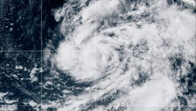
According to IMD Director General Dr. Mrutyunjay Mohapatra, the system began as a low-pressure area over the east-central and adjoining southeast Bay of Bengal on October 23. The agency projects the system will intensify into a depression on October 24, followed by a deep depression on October 25. By the morning of October 26, it is likely to become a cyclonic storm over the west-central Bay of Bengal before shifting west-northwest toward the coast. If the system reaches the threshold for a cyclonic storm, it will be designated Arnab under the regional naming scheme.
The primary impact zone includes north Andhra Pradesh and adjoining south Odisha. The Andhra Pradesh State Disaster Management Authority has issued cautionary alerts for districts including Vizianagaram, Manyam, Alluri, Kadapa, Annamayya, Chittoor, and Tirupati. Odisha is also expected to see enhanced rainfall activity as the system approaches. Officials warn that heavy showers could trigger waterlogging, localized flooding, and transport disruptions in low-lying areas. While the system is likely to bolster, a specific landfall point has not yet been confirmed, and the exact trajectory and intensity may change in the coming days.
India’s east coast is historically prone to such storms due to the warm, moisture-rich waters of the Bay of Bengal. IMD climatology indicates that five to six tropical cyclones occur over the North Indian Ocean annually, with peak seasons from March to June and October to December. The Bay of Bengal generates a larger share of this activity than the Arabian Sea. Odisha, situated along a main cyclone corridor, faces high recurring exposure, with records showing that intense cyclones have most frequently crossed its coast. Previous major events, such as Cyclone Phailin in 2013, highlight the region’s vulnerability to storms forming in this basin.
Current forecasting suggests the system will near the north Andhra Pradesh and south Odisha coastline around October 27–28. Authorities continue to monitor the storm’s development, with updates expected as the system transitions from a deep depression to a cyclonic storm. Residents in coastal districts are advised to prepare for adverse weather conditions, including lightning and powerful winds, in line with official IMD warnings.